Tuesday, May 24, 2011

Checking out app

App check out

Friday, December 29, 2006

1 in 60 Navigation

The 1-in-60 rule provides a rule of thumb based on the reasonably accurate assumption that the sine of any angle, up to about 45°, is equal to 0.1666 times (or 1/60) the number of degrees. e.g sine 30° is 0.1666 x 30=0.5 or 30/60 = 0.5. (There is an abridged trigonometric table in the Flight Theory manoeuvring forces module.) The sine is the ratio – in any roughly right angle triangle – of the length of the side opposite the angle, to that of the hypotenuse (the longest side), thus the 1-in-60 rule is handy in the mental arithmetic of flight theory and basic navigation as the angles involved are usually less than 45°. For angles up to 15° or 20° the tangent (opposite side/adjacent side) is practically the same value as the sine. For angles between 50° and 75° the sine is about 1/70 times the number of degrees, and for angles between 75° and 90° the sine approaches unity.

This rule of thumb can be used to determine track error, given distance travelled and distance off track.

Saturday, October 07, 2006

Paper on evaluating OpenSource software

http://www.dwheeler.com/oss_fs_eval.html

Saturday, September 30, 2006

Belize

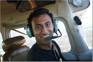
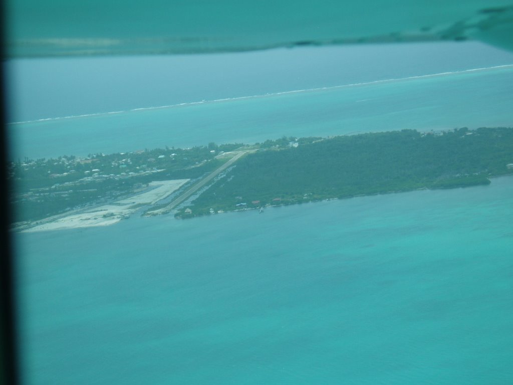
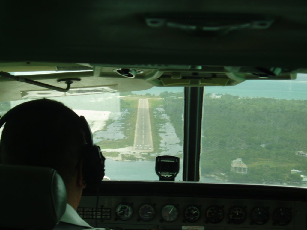
Ruth and I went on 2 week trip to Belize recently. It was a wonderful trip. We did a lot of scuba diving and plenty of laying in hammocks doing nothing.
In the second week of our stay there we took a 3 day sailing trip down the coast from our island home in Caye Caulker to Placencia in the south Belize. Our plan was to head inland from Placencia and see the rain forest and the maya ruins. However, on our way there we decided we had to dive the blue hole before we left the country. Since the best way to get to the blue hole is from Caye Caulker, we had to get back there from Placencia. The quickest way is by air.
Flying in Belize is really simple. There are two main carriers, Maya Island airlines and Tropic Air. It's impressive how well connected the small cities are by air. The workhorse of the fleet is the Cessna Caravan. It's a roomy 12 or 18 seater.

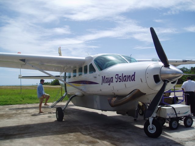
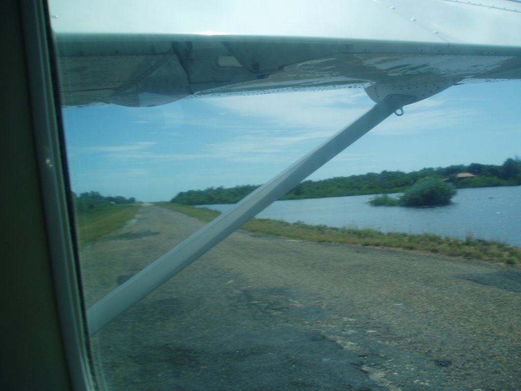
The interesting feature of the airports there is the runway. Most of the airports have a narrow paved road that serves as the runway. In Placencia, the runway cuts across the main road. There's a stop sign on the road that advises vehicular traffic to stop, look around for landing and departing aircraft and proceed! Here's a picture of the aircraft lining up for takeoff from Dangriga.


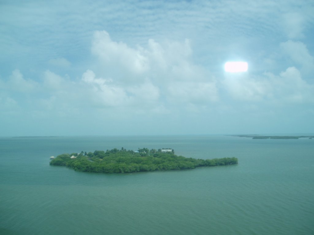
One of many small islands along the coast. This one was visible as we took off from the municipal airport in Belize city.


Base leg view of the tiny airstrip on the island we lived on in Belize, Caye Caulker.


On final approach for landing in Caye Caulker. This guys come in high and fast.

Thursday, September 07, 2006

SFO at 1500'

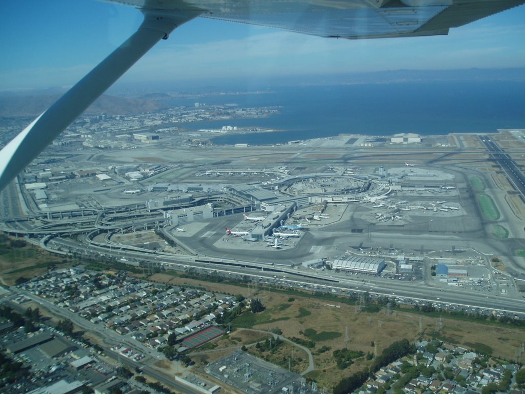
I took Ruth and Esther on a bay tour. It was the first time I flew out of San Carlos and with WFVC. I flew up the bayshore freeway, right past SFO and over the san bruno hill to SF. From SQL, the tower handed me off to SFO tower that cleared by through Bravo space at 1500'. It was neat flying so low and close to a major airport. I've been told that in some cases they let you fly right over the SFO runways.

Wednesday, August 30, 2006

Soothsaying two-year note

Interesting article from Reuters on how the yields on the 2 yr notes have closely predicted the fed rate changes.

-- From Reuters ---

NEW YORK (Reuters) - If you want to know what the Fed's next move will be, look no further than the trusty two-year Treasury note, widely seen as predictive of central bank interest-rate shifts.

A surge in the note's price, and accompanying drop in its yield, suggests investors are increasingly betting that the Federal Reserve's rate-hike cycle has peaked and that after a few months' hiatus the bank's next move will be to cut rates.

"The debate about easing rather than hiking is already taking place," said T.J. Marta, fixed income strategist with Royal Bank of Canada Capital Markets in New York.

Yields of Treasury notes and bonds of all maturities are well below the psychological 5 percent mark and further beneath the 5.25 percent of the overnight lending rate set by the Fed.

On Wednesday, the yield on benchmark 10-year notes slipped to a fresh five-month low of 4.76 percent on added signs that U.S. economic growth is slowing. The yield on two-year notes , which respond closely to expected shifts in the benchmark overnight federal funds rate, dipped to a near five-month trough around 4.82 percent, a hefty 43 basis points below the overnight lending rate.

------------

Assuming there are no major signs of inflation, it'll be interesting to see if this holds out. Other articles talk about how the collective wisdom of the bond market is quite good at predicting interest rate movements.

Saturday, January 21, 2006

Powerless in the sky

It was a beautiful september day in 2002, sky clear, unlimited visibility and moderate temperature. In my flight training, I was in the frustrating period between being confident as a solo pilot in the plane but not perfect enough to take the check ride. I quickly pre-flighted the 172 and taxied out to 27R. Run-up check...controls free and clear...fuel on...Carb Heat...1900 RPM...guages good..magnetos checked..ammeter charging...1000 RPM..radios..etc..etc. I couldnt wait to nail those power-on stalls and s-turns that had been dogging me.

Ten minutes after takeoff I was over Mt. Diablo. After about half hour of power-ons, turns and general loitering, I prepared to return to OAK. I dialled ATIS and noticed that my radios were really scratchy. I had seen that before and I did what's worked before, cycled the radios. Still no ATIS. A few more knob twists and headset connection checks later, I realised that my radios were completely dead. I had to land in the busy Oakland aiport and I had no radios to talk to the tower. I was in an in-flight emergency. The first few seconds are unforgettable. It was complete panic.

My student pilot brain took about 30 seconds to through all the doomsday scenarios and suddenly came to the realization that the plane was still flying and not dropping out of the sky. Good. I quickly checked all the other systems and pointed the nose towards to Oakland. What I simply couldnt remember was the radio failure transponder code. 7700 or 7600. It drove me nuts. After frantically searching my kneepad and actually thumbing through my FAR/AIM book, I guessed 7600. I hoped my transponder would be picked up by the tower so looked for light gun signals. Light gun signals! More frantic searching for what colors and flashes to look for followed. I planned to enter the pattern on the 45 and hoped traffic would be light. As I flew by the colosseum, I saw a game in progress. Suddenly a fresh wave of panic hit me. There I was flying a small plane, no radio contact with anyone, flying by a crowded stadium one year after 9/11. I scanned the horizon expecting to see a F-16 screaming towards me or worse a missile of some sort. No time to search for the intercept procedures.

By the time I turned downwind, I still couldnt make out any light gun signals from the towers. I proceeded on my base turn and scanned the runways. A plane ready to take off on the runway suddenly made a 360 and exited the runway. So, someone had noticed that I was coming. Final approach was perfect and a few seconds later, I was on the ground. As I taxied and parked, I expected someone from the FAA to drive up and hand me a sheaf of citations. Luckily, FAA didnt show.

After I got to the club, one of the intructors suggested I call the tower. We did and I was surprised to hear that the tower did not get my transponder signals at all and fired their light gun. I had lost all electrical power in the air. Thinking back, if I had been careful with my run-up check instead of racing through it, I may have caught the discharge in ammeter. I should've memorized the light gun signals, the intercept procedures (just in case) and ofcourse the transponder codes. Overall, it was a great learning incident. I was glad I experienced it. I was even more glad to be back on the ground in one piece.

Tuesday, December 21, 2004

Tide/Current Predictor

Tide/Current Predictor
"Anything under 1 would be fairly low and anything above three would be fairly high. The numbers correspond to the height of the sea above the mean level... I think. You will usually have two low tides and two high tides during one day. Usually one very low, one very high, and then one medium low and one medium high.

Regarding Pacifica, it is usually better on a high tide. On low tide, the waves will be crashing right on the sand. Also, in Pacifica, the further south you go (well, not too close to the rocks thoug), the easier it will be to paddle out." - Roland Vallet

Wednesday, December 15, 2004

Pelican's Perch #15:
Manifold Pressure Sucks!

Thursday, December 09, 2004

Weather Checklist

10 Days
1. weather.com : overall weather

5 - 3 Days
1.TV Weather
2.www.weather.com
3.http://aviationweather.gov
4. http://www.wrh.noaa.gov/mtr/satl.php:
For Radar & Satellite
5. Pressure system and precipitation forecast:
National center for environmental prediction
Check the forecast pressure systems and areas of precipitation at the forecast hour. Relate satellite and radar maps to the current pressure analysis, and the forecast precipitation to the forecast charts, to get a pretty good idea of areas where VFR might be a problem and whether it is going to be "getting worse" or getting better at time of interest. Select the current ("zero-hour") analysis, plus required forecast-hour chart. Lower left panel gives precip.

1 Day
1. National Weather Service - NWS San Francisco Bay Area:
Area Forecasts,
Low Level SIGWX Progs,
Radar (Local),
Satellite (Local)
2. FSS Briefing: Outlook

Day of Flight
1. West coast weather satellite
2. http://www.wrh.noaa.gov/mtr/satl.php:
For local Satellite imagery
3. http://aviationweather.gov:
AFs
Metars,
TAFs,
Winds Aloft,
Radar Summary,
Weather Depiction Charts,
PIREPs,
FSS Briefing

Tuesday, November 30, 2004

Stuck nose gear on 777
Interesting episode on our trip back to SF from St. Louis. The Denver-SFO leg was on a 777. Everything was as normal as can be till about 20 mins after takeoff. I heard a growling noise which I assumed was either the landing gear being lowered or the flaps being deployed. Both events that shouldnt be happening at that stage in flight. Odd. I was trying to remember the last time I was in a plane that had to return to the airport because of mechanical problems. Sure enough, the aircraft executed a slow bank for seemed like a 360. Few minutes later, the captain came online and said that we were returning to Denver because the nose gear would not retract completely.

I didnt hear if the nose gear was stuck in a semi-retracted state or was locked in full extension and would not retract. The former would not be good. I wondered if the 777 even had a hydraulic manual pump liked in the 172RG to manually extend the gear :). We circled for a bit. Not sure if it was clearance or to burn off some gas so that the touchdown weight is within limits. Thankfully we landed without incident and was escorted to the ramp by fire trucks and airport personnel on either wing and behind. Quite a sight.

It's too bad that they turned off the ATC radio comm that you can hear from the seat (Only on United). It would've been quite interesting to listen on on the exchange between the pilots and ATC as they prepared for the emergency landing.

Wednesday, November 24, 2004

Thursday, October 28, 2004

Financial Glossary

Op.Margin = Op. Income/Sales
Op. Income = Sales - (all expenses/costs)
Net Sales = Revenues
Gross Profit = revenues - cost of producing goods.
gross profit margin = gross profit/revenues
Op. Profit = Op. Income
Net Income = Sales - All expenses incl. taxes and interest payments
Net Profit Margin = Net Income / Revenues

Sunday, October 03, 2004

New Zealand

Finally, I made it to New Zealand. It was a fascination that took a grip on me when I watched some dicovery channel show about an ironman kind of race around new zealand. Unline most places that overpromise on TV and books and underdeliver, NZ lived up to the hype.
Auckland:
Cool city. Matt drove as around a bit. Checked out the beaches on both coasts on the same day. Walked into and around a crater of a volcano. One of many that Auckland is built on.
<< Insert Auckland Pic here >>
Wellington
Flew to Wellington the next day. Met a couple of locals at a bar. Walked around a little bit and headed to the ferry to Marlborough Sounds. Wellington is the southern tip of the North Island. It was a rainy and gloomy day. We were hoping the weather was local.
Marlborough Sounds
The drizzle had eased up so we were able to walk out on the deck of the ferry. It was a 3 Hr ride to the South Island. As we neared the sounds and the South Island, the clouds cleared up and it was beautiful. We pulled into picturesque Picton in the South Island. We checked into a hostel for the night.
Picton
Picton is a small town in Marlborough Sounds. There's not a lot to do in the town itself. There are a few nice walks. It's basically a launching site for tramping (hiking in kiwi speak) the Queen Charlotte track. Since it was such a beautiful day, we decided to Kayak the sounds.
<<< picture of kayaks >>>>
Ruth was particularly "thrilled" to kayak through hundreds of jelly fish in the sounds.
Christchurch
We didnt spend much time in Christchurch. We spent a night there and boarded the tranz-alpine across the south island to Greymouth. It was a good thing we booked early because the train was packed. The train ride itself was a downer compared to what we'd seen before and we would see later. The weather was also foggy so the scenic views were unimpressive.
Greymouth
Small town on the west coast of the south island. Got off the train and got on our little rental car for the rest of the trip
Franz Josez glacier
The drive down the western coast to the glaciers is quite beautiful. We reached the glacier at dusk and checked into our room.

Drive down to Queenstown, Queenstown, Glenorchy, Fiordland...so much to write ..so little time..... more later....

Thursday, September 30, 2004

Israel & Palestine

It amazes me how tragically idiotic the Israeli-Palestinian conflict is.
From the time the latest intifida started 4 years go, it's been a very predictable violent tit-for-tat. Suicide bombings followed by israeli incursions followed by bombings followed by more repression. It's unbelievable to me why there's no one on either side who can see the folly of the present situation.

The underlying problem is complex however nothing that either side is doing now is helping solve the problem. The Israelis are never going to have the peace and security they crave while continuing to occupy palestinian land and curtail palestinian freedoms. The Palestinians are never going to get self-determination and their land if they continue with suicide bombing of buses and restaurants. "An eye for an eye and a tooth for a tooth, leaves everyone blind and toothless" is what Mahatma Gandhi said. Looks like this conflict is out to prove him right.

I see a lack of true visionary leaders on both sides as the biggest problem. New leaders who envision peaceful coexistence as the ultimate solution.

Why can't the Palestinian leadership rally their people to engage Israel using peaceful means? Gandhi did it in India. Mandela did it in South Africa and MLK did it in the U.S. The world would have a lot more sympathy and understanding for the Palestinian cause, if they switched tactics. This will never happen under Arafat. It will take some strong-willed moderate to do this. A recent survey showed that three fourths of the palestianians populace preferred peace with Israel. Why wouldnt they after what they've been through?

The Israelis need to realise that no matter what security precautions they take, they are never going to safe unless the underlying problem of occupation is addressed. They have to stop expanding settlements. Remove punishing restrictions on civilian travel. They have to show that they are willing to improve the lives of the palestinians.


Monday, August 30, 2004

Columbia Airport
After many weeks of not being able to fly for one reason or the other (mostly weather related) finally everything came together; Plane, Weather, Time.
I've been waiting to go to Columbia for awhile now. At 2118ft, it would be the highest airport that I've flown too. I was thinking about coming out here for my mountain-checkout but after talking to another pilot, I decided I could do this myself and save the mountain-checkout for Tahoe.

Ruth and Pradeep came along for the ride. We flew out east and headed straight to Columbia. I was switching between my GPS and the navs for navigation (primarily the GPS). Once we were over the valley, the terrain has such a consistent look to it that finding landmarks was difficult. You can still identify the large water bodies and the like.

The airport itself is small. It's non-towered with a small FBO on site. The approach is not too technical. We landed, parked and took a short trail to the Gold Rush town of Columbia. After lunch and some lounging around we headed back home. I was hoping to experience some of the effects of the high density altitude but didnt. I guess I'll have to go over the sierras into Tahoe or Truckee to get a feel for that.

Thursday, August 05, 2004

Video of 747 doing a cross wind landing

Pretty cool video of a 747 doing a Xwind landing. I was beginning to ponder what kind of a Xwind would make a 747 do that but then I noticed the limp windsock in the corner of the video. So, it's probably a practice landing.


Tuesday, August 03, 2004

Cloud Clearance Requirements - Why All Those #*#%* Numbers?

A very good description on the reason behind the cloud clearances. I wish more instructors would understand and explain the reasons behind these kinds of requirements in this way. It would really aid in the learning process.

Thursday, December 18, 2003

100 Years of Flight
What better way to commemorate 100 years of flight on Dec. 17 than fly yourself? Thanks to the high pressure over the bay area, the weather couldnt have been better. High ceilings, visibility greater than 50, and cool temperatures. The folks at Kitty Hawk doing the wright flyer re-enactment would've been a lot happier and successful if they had weather like this.

I had initially planned to fly to Angwin but it was sunset by the time, we fuelled up and got 234JG in the air and I didnt think it was wise to fly over the hilly terrain into Angwin. I chose to head to Santa Rosa. This flight was also my first GPS aided flight. I bought a new GPS III Pilot on eBay and was eager to test it out. When I climbed into 4JG, I noticed that it had a large screen GPS in it so I ended up using that more than my toy.

The trip to Santa Rosa was great. The setting sun had spread a crimson hue over the sky. In the distance I saw Santa Rosa's runway 14 with it's blazing runway lights. - Night flying, while having it's unique challenges, is such an awesome thing -. After landing and tie-down, Ruth and I grabbed dinner at Manny's. The food was so-so. This is also Ruth's second trip to Manny's. Unlike me, she has a very low tolerance for bad food so she wasn't too thrilled about eating there. The trip back was nice. The moonlight illuminated the terrain not lit up by city lights.

Wednesday, December 17, 2003

Duats = "10546902"
AOPA Online [4250911]

Tuesday, November 25, 2003

Tool for calculating trip times.

http://www.ar-group.com/calc.htm


Friday, July 04, 2003

Cloverdale with the Guys

Nirma was in town over the weekend and as luck would have it I had a plane booked. Better still the weather stayed VFR. So, Nirma, Craps, BG and I headed to Oakland airport. Departure was as normal as can be. The weather was beautiful. We turned north and headed over the bay towards Cloverdale.

It was as small as I thought it was. I thought it would be a little more interesting though. It's just a simple strip by 101.

After we landed, we walked over to the only interesting thing around there, a dry creek bed. On our way back, we stopped over at Angwin airport. Now, that's a really picturesque strip nestled on a hilltop.

Wednesday, July 02, 2003

May, 2003 - St. Thomas, Virgin Islands.

A week in tropical paradise. One of the things that pushed me into flying was the idea of flying around beautiful islands with white sandy beaches and turquoise waters. Ever since I read R.L.Stevenson's Treasure Island as a kid, the allure of tropical islands with white sands and lush vegetation has been ingrained in my head. So, when the trip to Virgin Islands became a reality, I was not going to miss an opportunity to fly around. Even before I bought tickets to St. Thomas, I had checked up on FBOs on the islands and found out who rents planes. 'Ace flying club' was the only on in St. Thomas that rented C-172s. It was $100/hr (wet hobbs) with a checkout that cost $120 incl. the flight time. Perfect.

After a couple of spectacular days rollicking in St. thomas and the neighbouring isle of St. John. I went over to Ace's to get checked out. The checkout itself was quite a trip. The C-172 looked like a weather-beaten sailor but who cares if the the seats are a little crummy, right? The CFI gave a quick overview of the bird and told me where the life vests were - in case we stopped in the 'drink'. Soon, we were aloft flying between two hills over downtown st. Thomas and marina. Over the turqoise waters, I showed him some stall recoveries and some turns-around a beach ringed isle. The CFI signed me off and commented that my instructor had done well. Kudos Chris!!

Time to go sightseeing. Ruth and her friend Renee were going to go on the trip with me. Jim (Renee's boyfriend) decided he would like his feet on terra firma so opted out. So, me and the girls headed out to the plane, I did all the pre-checks and we were off into the crystal blue skies. We went over the St. Thomas harbor where all the cruise ships are docked and did some sweeping turns around the island itself. I headed out to St. John, the next closest isle. From St. John, we flew over some of the British Virgin Islands and some other random islands. With Ruth clicking away, we got some pretty cool pictures.

On the sectional map, I had noticed a tiny airstrip on a tiny island to the north west of st. thomas. I had asked the CFI about it but he cautioned me that it was a tricky approach. The island was called 'Isla De Culebra' and it's part of Puerto Rico.

After loitering over the british virgin islands a while, I decided to check out Isla de Culebra. We flew over the open caribbean sea to this little island and circled it. After debating about landing there, I decided to heed the CFI's caution and just overfly the strip. When I called in to say my intentions, the response on the CTAF was in spanish! That was quite interesting. After that little excursion, we decided to head back to St. Thomas. We flew into right pattern for Runway 10 at the Cyril E.King airport in St. Thomas and made a fine touchdown.

That was truly one of the most memorable flights in my life.


Friday, April 04, 2003

Surfing

Now, every self-respecting coastal californian should've done some surfing. Sure, the waters around SF can send you into hypothermia in minutes but that's what they have wetsuits for.

Ruth and I decided to plunge into surfing this year. Roland (my colleague) is an avid (or should i say, rabid) surfer. We tagged along with him and went out to sea. We rented wetsuits and boards in Pacifica and took to the beach. After about 3 minutes of instructions, we were in the water, try to figure out how to get our bodies on the damn board without having the waves tip us over. To add to the difficulty, I had a hole in my rented wet suit somewhere in the crotch area so needless to say, it wasn't a very pleasant experience. However, I did like the sport and decided that I would get my own wetsuit. That would also get me invested in the game.

All that's needed is practice, practice and more practice.

Wetsuit Guides
http://www.croyde-surf-cam.com/onlinesurfschool/wetsuits.htm
http://www.santabarbarasurfing.com/guide/wetsuit.html

Thursday, April 03, 2003

Flight Tips

Density Altitude

An accurate rule of thumb (usually any error will be less than 300 feet) for determining the density altitude is easy to remember. For each 10-degrees Fahrenheit above standard temperature at any particular elevation, add 600 feet to the field elevation. (And, conversely for each 10-degrees F below standard temperature, subtract 600 feet.)

Standard temperature at sea level is 59-degree Fahrenheit. For elevations above sea level, subtract 3.5 degrees per thousand feet of elevation (lapse rate is 3.5deg/1000ft) from the sea level temperature of 59 degrees. For example, at Jackson, Wyoming the elevation is 6,444. Multiply 6.444 times 3.5 for 22.55. Subtract this from 59 (59-22.55) for 36.45. The standard temperature at Jackson is 36.5 degrees. If the existing temperature is 80 degrees, subtract (80-36.5 = 43.5). Divide this difference by 10 degrees (for each 10-degrees F above standard), and multiply 4.35 times 600 (600 feet per 10 degrees) equals 2,610. Add 2,610 to the field elevation (6,444) for a density altitude of 9,054. Under the existing conditions (of our example), the airplane will perform as it would on a standard day at 9,054 feet elevation.

Monday, March 17, 2003

March 16, 2003 - Oakland to Santa Rosa.
I had joined Alameda Aero Club the a week ago and was eager to make use of their (cheaper!) planes. So, the plan was to go to Monterey and spend the day there. Thunderstorm activity started late in the week and continued into the weekend. Sunday saw the tail end of the bad weather but it was still low clouds, ceilings between 3000 - 4500. Up over the ocean beach, it was clear and it seemed like the dark stuff was moving south-east quickly. I decided to go to Santa Rosa instead. Monterey trip needs better weather.
By the time we taxied on to the runway in 234JG, the scattered layer was quicky becoming even more scattered. The trip to STS was great. Unrestricted visibility, scattered clouds at 4500.
Got into santa rosa and had brunch at Manny's. Decent Food. Good OJ :). There was a light drizzle when we landed and by the time we were getting ready to leave, it turned into hail. It started pouring so we just sat in the plane on the ramp. I could see it was clear and sunny everywhere to the west and south west and the it looked like the rain cloud was moving away. Sure enough, the hail subsided and we left. On the return trip, We went over point reyes and flew down the coast. While I was looking out to see which hole in the clouds to drop through, Ruth was furiously snapping pictures. She realised that she loved to fly over the coast. The cloud layer over the coast was 2000 - 2500 scattered. SF Bay itself was clear and beautiful. We flew slightly north of the GG bridge and down into OAK.

Tuesday, March 11, 2003

Tuesday, March 04, 2003

March 23, 2003 - Oakland to Half Moon Bay.
VFR weather. Ruth, BG and Rams (Houston) on board. This is my second trip as PP-ASEL :). It's hard to get a chance to fly to Half Moon Bay because it's so close to the beach and it gets fogged in very quickly. Anyway, today we were luck. We flew through SFO Class B airspace, over palo alto, over the hills and into HAF airport. We tied down and went for brunch at '30 cafe'. One of the best OJs I've had. While the others seemed to be enjoying a good meal, my eyes were directed at the sky outside. The clouds were rolling in fairly quickly. By the time we were ready to leave, there were few clouds at 800. Managed to dodge 'em and depart. We headed up the coast around the city, over the golden gate bridge and landed back in Oakland.
Space and Beyond

"The earth is too small and fragile a basket for the human race to put all it's eggs in"
- Robert HeinLein

I can't wait for the day when space tourism becomes commercially available. Hopefully the 'X'prize project will spur more progress in this area.

Friday, October 11, 2002

U: 03105730240
A: 35H7H74
HZ: 36720587
Site Meter